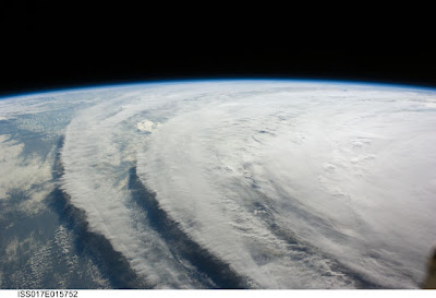
 (Hurricane Ike from the International Space Station, photo by NASA)
Hurricane Ike -- Update Friday Evening, 12 September 2008
The grim forecast for Ike has not changed and in some ways has worsened. Honestly, evacuation is what you need to do if you live in its direct path on the Texas Gulf Coast.
Thanks to reader Kent's comment from yesterday's post here, I've discovered the best blog ever for understanding this hurricane, Dr. Jeff Masters' WunderBlog. Dr. Masters co-founded the Weather Underground in 1995 while working on his Ph.D. at Michigan, and flew with the NOAA Hurricane Hunters from 1986-1990All of the information in this post comes from his research, so hop over there for the latest. I'll quote a small portion of the excellent information he has on tap:
"Although still of Category 2 strength, Ike remains larger and more powerful than Category 5 Katrina or Category 5 Rita. As I discussed in yesterday's blog entry, a good measure of the storm surge potential is Integrated Kinetic Energy (IKE). Ike's Integrated Kinetic Energy has fallen from 149 Terajoules this morning to 124 at 3:30 pm EDT this afternoon. However, this is still larger than the total energy Katrina had at landfall, and Ike's storm surge potential rates a 5.1 on a scale of 1 to 6."
"Ike is attempting to create a new eyewall, and visible satellite loops and Galveston radar suggest the storm is becoming more organized. However, Ike has only a few more hours over water, and there is not time for the hurricane to intensify more than 5-10 mph before landfall. Ike will not inflict extreme wind damage like Katrina's or Rita's. The big story with Ike will be the storm surge." (Illustration of Storm Surge Guidance for Texas and Louisiana Gulf Coasts, Friday -- image from NOAA. Click to enlarge.)
"According to the NOAA) tide gauges, storm tides are running 6-8 feet above normal along the central Louisiana coast this afternoon...The fact that Ike's storm surge has reached such high levels 200-300 miles north of the storm is a very bad omen for the upper Texas and western Louisiana coasts. The latest forecast surge values from NOAA):
Shoreline of Galveston Bay... 15 to 22 feet
Bolivar Peninsula... 17 to 20 feet
Galveston Island... ... 14 to 17 feet
Gulf-facing coastline from Sargent to San Luis Pass... 8 to 14 feet"
Dr. Masters is predicting that Ike will flood the city of Galveston. He states "If the surge exceeds the 17 foot forecast, it will overtop the sea wall and act like a battering ram against the buildings in Galveston. It is also possible that the sea wall will be destroyed along some sections, allowing the ocean direct access to Galveston." Shades of 1900. (A formerly populated area of Galveston four blocks wide, half mile long, which was wiped clean by the storm surge during the Hurricane of 1900; complete pictorial plus some of the earliest films ever taken in the aftermath available at The 1900 Storm.)
Dr. Masters also predicts "significant tightening of gas supplies in coming months, due to extensive damage to the oil refineries in the Houston and Port Arthur area." Regarding Houston, he states "Nevertheless, winds of Category 1 hurricane force (75-85 mph) will affect the city for about a 4-hour period in the early morning hours of Saturday. People in well-built homes will suffer only minor damage, but mobile homes and homes not build to code will suffer significant damage. The extremely long duration of the hurricane force winds will cause much greater damage than is typical for a hurricane of this strength."
He goes on to discuss the Inland Wind Model developed by NOAA scientists and has an excellent graphic and explanation at the link above. In this section, he states "We can expect Ike to cause the largest and longest-lived power outage in Texas history, with power knocked out along a 200-mile wide swath in eastern Texas and extreme western Louisiana extending 300 miles inland to I-20. Dallas will be at the fringe of the region of widespread power outages, and should not suffer major power failures." Our local news has repeatedly warned of the possibility of local power failures. I've pulled out my candles and have my crank-powered radio/flashlight handy. I've also backed up my hard drive to an online briefcase, and topped off the cat's self-serving food and water supply. I need to go cook what I can from my refrigerator in case I have to go a couple of days without power, and fill up water bottles plus a bucket for the toilet.
Austin has taken a large number of special needs refugees at our local hospitals, including many premature infants. The shelters are filling so rapidly that all our local schools closed early today, in order to convert them into evacuation facilities. Stay in touch, folks, and help where you can.

Friday, September 12, 2008
Hurricane Ike -- Update Friday Evening, 12 September 2008
Maggie Jochild 3:51 PM
Labels: Dr. Jeff Masters' WunderBlog, Galveston, Hurricane Ike, Hurricane of 1900
Subscribe to:
Comment Feed (RSS)


|